Aalborg tests in-house 3D design of own roads
The city of Aalborg has started a pioneer project to check out the benefits of in-house 3D design of its own roads. A 4,3 km long municipal road is currently being designed with Trimble´s BIM tools Novapoint and Quadri – whilst simultaneously building up the municipality´s own 3D engineering skills.
“Unfortunately, we have no prior experience with either 3D modelling, nor design of major roads, so the project is both exciting and enlightening”, says Jannie Leth Petersen, project manager for the pioneer project. “As a rule, we have used to subcontract the larger engineering projects to consultants. On our own we have so far only designed smaller roads, traditionally in 2D.”
Comprehensive extension
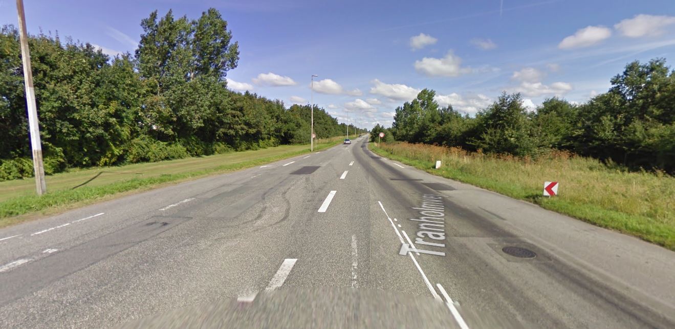
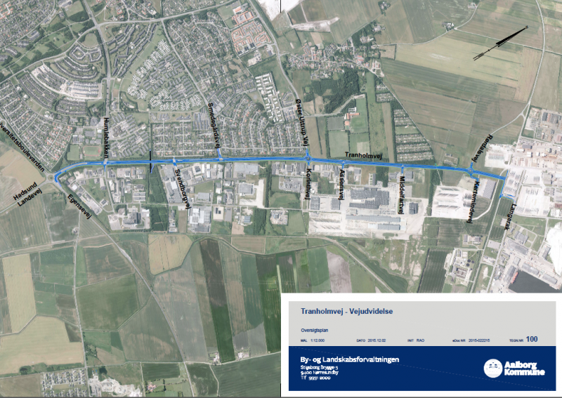
The pioneer project is in fact an expansion and modernization of the 4.3 km long existing Tranholmvej in the outskirts of Aalborg city centre, not far from the harbour. The road, which currently has partly two and partly four lanes, will be expanded and redesigned into four lanes all the way, plus get a new bicycle path alongside. The project also includes signalling, water diversion and road marking etc., in addition to new roundabouts and adjustments of existing ones.
The municipality has appointed a project team of seven people to carry out the new road design; a project manager, three engineers and three assistants. The project has a budget of DKK 100 million and aims for completion by the end of 2019, given that the project is granted necessary funding year by year.
From 2D to 3D design
“The team belongs to a department responsible for the planning, design and operation of our municipal roads”, says engineer Jakob Kroman Bjørn. “As planning tools we have so far used Trimble Novapoint Road to design our smaller roads in 2D. It´s actually several years since the department invested in three software licenses, but the tool has unfortunately not been fully utilized since we have dealt with only small projects.”
The development of new 3D and BIM technology in recent years has however opened the possibilities, the engineers tell. New modelling solutions enable developers, consultants and contractors to collaborate much closer using a model of the project, rather than with traditional drawings – which also result in increased efficiency.
The challenge is that the collaboration also introduces consequences for how the projects should be planned and carried out. On the other hand, the BIM methodology also means that project owners now to a greater extent can set the agenda themselves and point out the direction of the projects.
Use BIM tools
And this is precisely what Aalborg Municipality has decided to test in the Tranholmvej project. As engineering tools the project team has decided to use Trimble´s (formerly Vianova Systems) BIM solution Novapoint Infrastructure Design Suite (IDS) and the model server Quadri.
The solution combines nine different discipline tools for designing the different parts of the infrastructure, together with Quadri, Trimble's cloud-based BIM server and collaboration platform. The discipline tools in Novapoint IDS enable the design of all aspects of a modern road, including terrain and landscape, intersections, roundabouts, road marking and signs, water diversion and ditches, as well as tunnels and bridges. The Quadri model server is an object-based database tool that allows the disciplines to share a common project model – enabling all stakeholders like planners, designers, contractors and project owner to collaborate closely.
Pioneer project
“The project began in the springtime of 2016”, continues Kroman Bjørn. “But since we have not used Novapoint that much earlier, and only for 2D drawing, we are still in a relatively early phase of the project. 3D design requires some restructuring, both individually and methodologically.”
“For the department, this is a pioneer project where we as we go build up our own expertise in 3D modelling using the new tools. Hopefully the results will motivate the municipality to do more of the same going forward. The project is also a test for the team to see how big projects we can manage ourselves internally.”
From terrain model to complete road model
“We initially built the terrain model of the existing situation, then added road alignment, longitudinal profile and plane geometry. We are now fully into the 3D modelling”, tells Jannie Leth Petersen. “For efficiency reasons, we have divided the project into eight road models that we share between us. The road models are automatically assembled into a joint complete project model in the Quadri database. Everyone can therefore work simultaneously and independently on each individual sub-models. This is a great advantage when several people are working on the project.”
Quality assurance
“We can all the time see what the others are doing and see how it all fits together. This way we can rapidly detect and correct errors and omissions”, adds Karina Smith Christensen, another of the project participants. “It´s therefore timesaving in several ways. You get a far better overview, you see the whole model constantly, and you immediately see if there are conflicts with the other road models.”
In addition to the actual road design there are other engineers on the house working with road signalling, traffic safety assessment etc. Engineering services such as geotechnics, pavements, water diversions and noise assessments, are being conducted by external consultants.
New way of thinking
“So far everything has worked very well”, assures Jannie Leth Petersen. “We have not encountered significant problems. However, 3D requires that you have to change mindset and your own way of working. You must think in three dimensions, not only in 2D. This is actually a pretty big transition when you have worked in 2D for many years.”
Structure and discipline
“The work methodology also means that you have to make certain decisions and preparations about the model structure up front, before you start modelling”, says Kroman Bjørn. “When there are many designers who are dependent on each others work, you must have a common structure and clear guidelines, otherwise you will quickly run into problems. 3D design requires more work discipline, but it´s for sure everyone's common good, and the result is so much better.”
New inspiration
“For us who work in the department it actually also means new motivation”, remarks Ragna Olesen. “It is both inspiring and exciting to work with the new 3D tools. It's fun to go to work, although it is also challenging. You have to use your brain in a completely new way and think in multiple dimensions. Not only lines. Using the model, suddenly everything becomes understandable to all, enabling everyone to be more involved in the planning. Everyone is now seeing the whole “picture” and can contribute in a more creative way. This is more inspiring, fun and effective.”
Besides getting support from Trimble Aarhus when needed, the engineers also have an experienced person at Rambøll Aalborg who they can contact, especially when it comes to practical engineering solutions. This is both reassuring and of great help, it is stated.
Storage in the Cloud
“Besides, the solution also provides comfortable Cloud storage”, points out Jacob Kroman Bjørn. “Our project model is stored on a BIM server in the Cloud, which Trimble handles. We just have to concentrate on our engineering tasks. The solution provides automatic data security and backup, avoiding also considerable costs and resources in running our own server.”
Important to follow the trend
For municipalities, like other project owners, it is obviously important to follow the digitization trend. For instance indicate recent developments that also municipalities have to take advantage of BIM models in due course. Not only building models, but also infrastructure models, above and below ground. And not just during the design phase, but also all through the construction process and later in the operational phase. Models, not drawings, are becoming the key information carrier and the collaboration platform in new infrastructure projects.
“In the city of Aalborg´s history, the Tranhomvej project is a unique project in several ways”, says Jannie Leth Petersen. “Not the least because of the road´s location between residential areas, industry and the harbour. There are many considerations to be made, requiring close collaboration between many stakeholders. We already see that our digital model of the project will be very helpful also in this context.”